Introduction
The idea of visiting Faroes came to my head in the Autumn of 2018. I remember watching vlogs on YouTube from some great photographers and I fell in love with this place immediately. My desire of going there was so big that I decided to abandon long-time planned visit to Iceland. This small archipelago of 18 Islands lies on the North part of the Atlantic Ocean, between Scotland and Iceland. Some people call it the last secret of Europe. Well, not so much a secret anymore as the popularity of this place grows every year, bringing tourists and photographers from all over the World.
In this article, I am going to introduce you to some of the magical places of the Faroe Islands and hopefully, let you feel the charm of the place.
But first, a few things about planning.
The best and easiest way to get to Faroes is by plane. Flights operate from Copenhagen and Edinburgh but soon also from other places in Europe so stay tuned. I used a local Faroese airline called Atlantic Airways. I also heard about plans of opening a route from New York. Flights tickets aren't that expensive. I paid 260€ for the return journey from Edinburgh and that was with checked-in luggage and hand luggage. From Edinburgh, it takes a little bit over 1 hour to get to the main Faroes airport on Vagar island. Faroe Islands are small but the best way to travel when there is to rent a car. I have to warn you about prices. Faroese look after the archipelagos nature and car rental has environmental tax, which significantly increases the prices. The best is to travel with somebody to spread the costs. To rent a medium size car (Toyota Avensis) I had to pay almost 1000€ per week. That was including insurance, waivers, and tunnel charges. The cars are brand new and very comfortable. Tunnels are quite expensive and you will be driving through them a lot so the best is to buy an unlimited pass when renting a car. I would recommend a company called 62°N
There is plenty of accommodation to rent and if you start looking early enough, it will be at reasonable prices. I visited Faroes twice already and on both occasions costs were around 500€ per week for a specious house or apartment. People on Faroes are very nice and helpful.
The weather on the Faroe Islands is unpredictable. Quite often you will experience 4 seasons within 1 hour. It could be lashing in one place and the sun shining 30 minutes drive away. For that reason don’t forget to pack plenty of wet gear and spare clothes. Also a couple of hats and gloves. My visits were at the end of April 2019 and the end of January 2020. Especially on my second visit, I experienced the worst weather in my life. Rain and the gusting wind was my companion for almost a whole week. The wind makes this place extremely dangerous. I experienced a gale force of 120 km/h. Try to imagine how would it be on a cliff or mountain in such bad weather. On my last trip, I was photographing mostly handheld and obviously not as much as I wanted. Some places were just impossible to reach. So be prepared that your trip might end up not so well. I had definitely much more friendly weather during my first stay in April. My recommendation for visiting Faroes would be from March to October. Be extremely careful when hiking as fog can come suddenly out of nowhere and you don’t want to get lost. Also, watch yourself on the cliffs as some of them are as high as 700 meters. Falling off would certainly mean death.
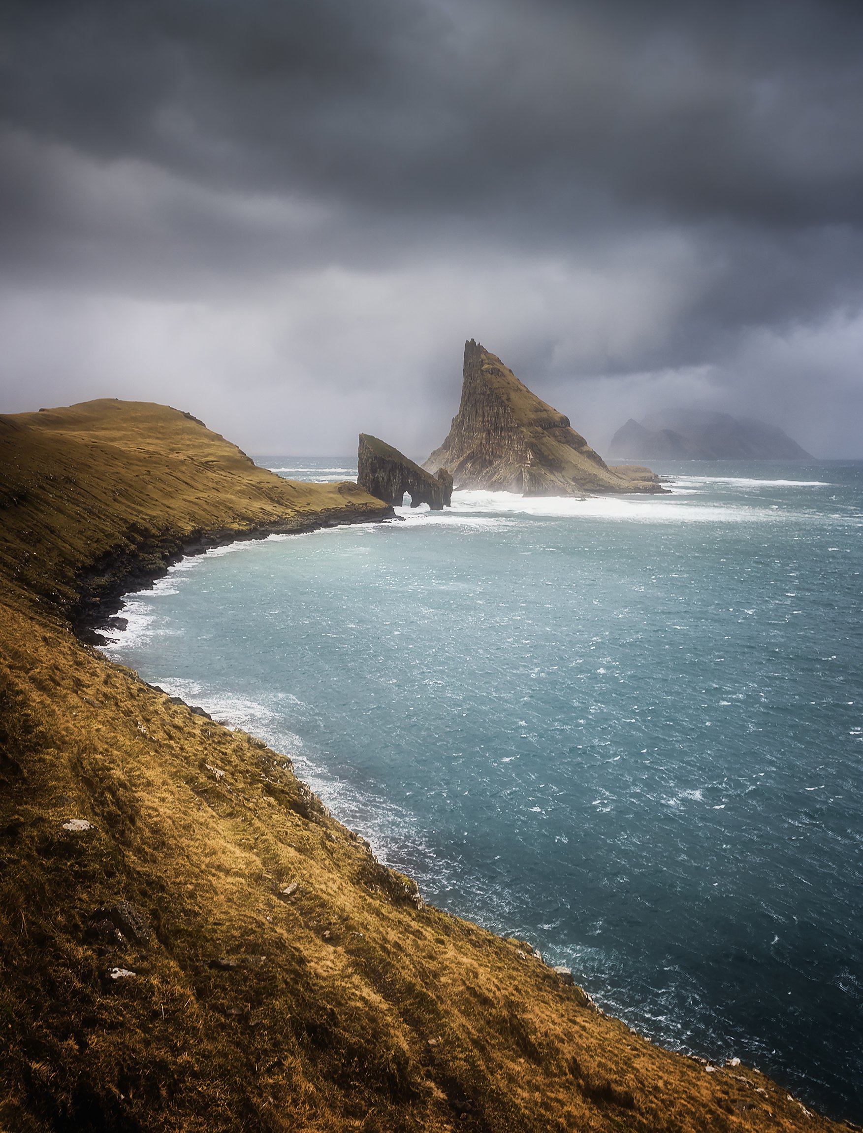
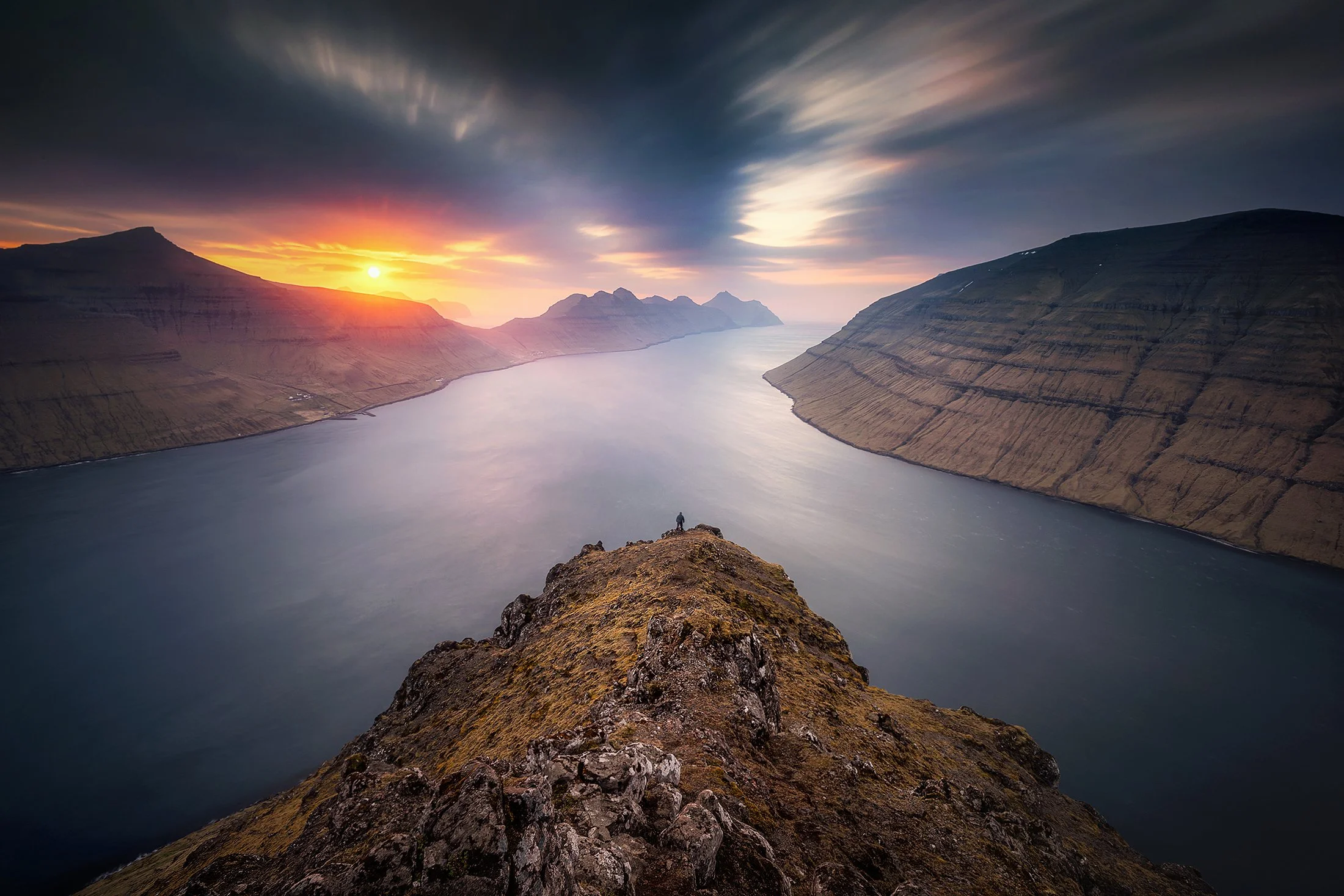
DRANGARINIR, VAGAR
In this blog, I will go through all islands of the archipelago, one by one, and try to be as specific as I can. First, you can take a look at the map below. How amazing the Faroe Islands look. Only by checking the map, you can say there must be something worth seeing.

Faroe Islands Map
VÅGAR
Vågar island is known among photographers as a dreamland to practice their craft. You will find here everything from lakes, mountains, massive cliffs, and amazing rock formations to charming settlements and wildlife. The weather of Faroes, as I mentioned in the introduction, gives the opportunity to achieve unbelievable results. If you’re lucky of course. You can reach any place by car within 30 minutes. By reaching any place I mean start points for hikes. You have plenty of them here. Most of the hikes in the Faroe Islands require passing through private land so make sure you treat local people's property with respect. Most of them are paid so get ready for some serious spending. Prices start from 25€ but sometimes can reach even 360€ as some farmers require to hire a guide. That’s why I mentioned earlier that it’s a good idea to share this trip with at least 1 or 2 friends. Guide charges for half day walk regardless of how many people are in the group (reasonably). As far as I know, on Vagar guide is required to get to Drangarnir( 6 hours) and Trælanipan (3h). Especially the first trip is quite expensive.
Trælanipan, Sørvågsvatn, Bøsdalafossur
Trælanipan cliff is the first place I’d like to take you to. The narrow road after the Magn petrol station in the settlement of Sandavågur will bring you to the cabin. Here you’ll find the gate for your hike. I was there 3 times and never met anybody so my trip was free. Maybe it was because of the time I was visiting Faroes. From there you have a roughly 40 min easy hike along the biggest lake on the archipelago called Sørvågsvatn.
Trælanipan cliff & Sørvagsvåtn lake

Trælanipan means Slave and it got its name from the time of Vikings. Apparently, slaves have pushed off 142 meters high cliff. I also heard from locals that in the case of the death sentence, there were no trees on the archipelago to hang the criminals so they used mentioned cliff. It isn't the place for the heart fainted. It takes a little bit of stronger wind, from the wrong direction and it could end badly for you. So be extremely careful and if you know it's going to be windy just don’t go there. I had a chance to photograph it on a moody day and also in the sunshine. It looks brilliant in any weather. It’s just one of these places you don’t want to leave. There is so much to do you could easily do a whole day of shooting, from sunrise to sunset.

On my 2020 trip, I attempted to fly a drone over a cliff. I sent the aircraft into the Ocean, looking for some good perspective on the cliff, but western wind pushed it over the lake. I completely lost control of the drone which ended up in the airport no-flight zone. Safety features in aircraft made it to land on the lake. I thought it was gone but last minute, I managed to regain control over the device and moved it towards the shore, except it was the other side of the lake. In order to get my drone back, I had to cross the river, come out of the lake, and fall into the Ocean 80 meters further. Normally that river is narrow and shallow but it was raining a lot, so this time water was much deeper. I got in a bit of trouble, halfway through, where it was deepest and current strongest. I expanded my tripod legs and helped myself keep my balance. Thank God I made it. I got my drone back but I was absolutely soaked. Not wanting to risk it again, I decided to walk back to the other side of the lake, which was an additional 7km.
If I didn’t have wet boots, this walk would probably be enjoyable. Days were short and I was waisting 1.5 hours for this hike, instead of taking photographs. It was a good decision to take my camera out in case something will appear. I was approaching some cabin house in the middle of nowhere. A few shots taken cheered me up a bit. I finished my walk around the airport where my companion was waiting for me in the car. Now imagine if there was nobody who could pick me up and after a 7km walk along the lake, I would have to do another 7km to get back to the car. Phew… that would be some hike.

Cabin house at Sørvågsvatn Lake
A couple of minutes walk West, will bring you to the edge of the cliff and another magnificent location called Bøsdalafossur. This is the place where lake water falls into the Ocean from 30 meters high cliff. On stormy and windy days, huge waves come over the cliff and the wind blows the waterfall up. You can experience spectacular views of Vagar cliffs and the magnificent sea-stack called Geitisskoradrndrangur.
Bøsdalafossur & Geitisskordrangur

When you are in this area, after visiting the cliff and lake, you can also enjoy another rock formation called Trøllkonufingur which in English means Witches Finger. You easily tell why.
Trøllkonufingur

313 meters high monolith, sticking out from the mountain around Sandavågur is easy to access and it’s visible from many places. You can walk close to it but you can also shoot it from across the water, including other elements like sheep or cabin houses. The legend says that the witch came to the South shores of Vagar, trying to throw the Faroe Islands to Iceland. When the sun came out, she turned into stone and sank. What was left after her is the finger sticking out of the water. Sun rising behind it can give amazing effects. Unfortunately, it wasn’t given to me but I think a moody day can also provide satisfying effects.
I mentioned before how dangerous fog can be on Faroes. It really appears from nowhere and you don’t want to be far away from civilization when that happens. Lady who I rented an apartment from described it is a funny but also scary way: we have had a problem with tourists recently…they die. As she explained later a lot of people hike unprepared and get lost. The main advice, I got from the local guide was, if the fog comes, just stay where you are until you see your way. Doesn’t matter how long it takes. Just don’t move. For that reason, you have to be well-equipped for your hikes. Make sure you have warm clothes, plenty of water, and something to eat. Always have compass with you and your phone fully charged. It's a good idea to have your maps downloaded in case of no reception. If the worst comes you can always call rescue service. I went on a hike to some lovely stacks on South West coast of Vagar. There was no trail. Normally it would probably be a pleasant walk but halfway up fog appeared. I was prepared but still didn’t feel comfortable. I continued walking as according to satellite view, there should be a clear sky over the Ocean. From Sørvågur settlement, close to the ferry and a small petrol station, you need to walk straight up the mountain. The best way is to follow the river all the way to the lake at the top. Pass the lake, turn left, and just follow the coast. Naturally not too close to the edge as the cliff is very high.
The hike is around 3.7km one way, including 2km straight up the mountain, and rests up and down. Following the coast on the top will take you to a magnificent spot, the name I don’t know. The place is full of birds and the sea stacks are spectacular. As I was going up, the fog was getting thicker and I kept walking right direction only thanks to phone navigation, showing my position. A few times, I was ready to turn back, but I remembered how much cost me to do the first 2km up the hill. I was right about a clear sky over the ocean but arrived a bit too late and the fog was still covering most of the cliff. It was very difficult to shoot flying birds in low-light conditions. However, I managed to get one or two shots, documenting my trip there.
Sea stacks on South West of Vågar

Next to this location, you will find probably the most spectacular place you have ever seen called Drangarnir. It's a 14 km round trip but I promise that you will be rewarded. The hike starts from HiddenFjord seafood wholesaler and it takes roughly 2 hours. First time I was there I had to hire a guide which cost me a fortune. Luckily, I could spread the costs with my companion but it still was a big part of my budget. As far as I remember we paid 460€ to access the land and the guide time. Guide was a very friendly Danish guy with excellent English. If you are stuck, I can recommend him. His name is Thomas Vikre.

On my second visit, Thomas was away so I took a chance and walked there myself. I was of course prepared to pay. I just knew the owner, who lives just across the water, will be waiting for me. When we walked back to the gate he was there. I explained that we couldn’t get the guide because of the time of the year. He advised us to call him next time and asked for a fee. This time it was only 50€. He had a little chat and he promised he will sort out the boat collection for us next time. Not too shabby. It's nice to be nice as I always say. The first time, I visited Drangarnir, Faries was under influence of a sand storm from the Sahara. Yes, that is correct….Sands from Sahara deserts. Because of that sunsets were very hazy and orange. To be honest I wasn’t expecting any fireworks when walking over.
Drangarnir cliff and Tindhølmur

Dranarnir hike is not hard but extremely long. Especially when you come back tired from the 7km you already did and from all excitement you experienced running up and down the cliff. I never forget my second visit in January 2020, because of the windy conditions and hail showers attacking us every few minutes.
When I finally reached my destination, I didn’t even know where to start. It has a big wow factor believe me. The cliff is phenomenal, the waves on the Ocean astonishing and the sea stack overwhelming. The whole place is like a touch of God. I promised myself that regardless of how many more times I visit Faroes, I’ll always visit Drangarnir. Compositions here are limitless and where ever you stand you see it…your shot. All you have to do is wait for some good light.

Being there 3 hours before the set, gave me some time to suss it out a bit. I ran up and down the cliff twice and I still had a good 1.5 hours to sit down, relax and watch this beautiful scenery. During my 2 visits, I haven’t experienced any amazing light but also it wasn’t too bad. I am very eager to go back there as soon as I can. The best conditions for photography I had during my April visit. I ran down to the bottom of the cliff and walked over the rocks, very close to the Ocean. Sun was almost gone but the sky looked lovely, due to the Sahara sands, I mentioned before. When you standing there, you have to be extremely careful not to get washed. On my second visit in January, I wasn’t even able to walk down there as it was life-threatening.
Drangarnir seastack

The next stop on Vågar island was Gásadalur. A very picturesque village, built at the end of Mykinesfjørðuron, on the cliff, with a waterfall in front and a mountain at the back. This place used to be accessible only by a long hike across the mountains or by boat. In 2004 locals built tunnel through the mountain, linking the village with the rest of Vågar. From that time, Gásadalur became one of the most visited and photographed places on the Faroes. It’s one of the not many places on the archipelago, not require a hike. You just get off the car and photograph. For that reason you need some special conditions, making your photo stand out from millions taken there.
GÅSADALUR VILLAGE

I was lucky to visit this place maybe not in the greatest light conditions but with some nice moving clouds. On another occasion, I had more movement on the water than in the sky. Getting the right moment, with all elements working in your favor is very difficult, when you spend only a week in such a fantastic place, with so many other things to photograph.

When I was visiting Faroes at the end of April, I came across Puffins colony. Gåsadalur is one of the places where you can see them, as they have their nests in the cliff you'll be photographing from. I didn’t have much time to spare for this beautiful birds but I managed to take a few snaps.
PUFFINS IN GASADALUR


The most known place you can photograph Puffins is on a small island next to Vågar, called Mykines. Thousands of birds come there at the beginning of May from Canada. Unfortunately, I did not have enough time to get there, but I will tell you about a few options you have. Mykines are fantastic locations for both landscape and wildlife photography. Because boats start their operation 1st of May and I was there in the last week of April, I had to skip it. You can get your transfer from the Sørvågur ferry pier. My guide Thomas, told me that approach to Mykines is very difficult due to the rough waters and in May 2018 most journeys were canceled. Boats landed on the island only a few times during the entire month. Be prepared for disappointment. The other option is to take a 60 Euro helicopter flight but you have to remember that you won’t be able to return the same day and also that you have to book it in advance. I say if you have 2 or 3 days to spare, the helicopter option is not too bad. There are plenty of hikes on Mykines and a lot to see, so it won’t be a time waste. There is also some accommodation available on the island between May and September. Because I wasn’t able to go, I didn’t look into it so much and I can only offer you a view of Mykines, which I photographed on my way to Gåsadalur.
MYKINES

Except for nice view on Mykines, there are also a few nice views across the water, towards Drangarnir. It's really worth stopping at Bøur settlement and enjoying the view.
DRANGARNIR VIEW

BØUR SETTLEMENT AND DRANGARNIR

The last place I wanted to show you on the island of Vågar is very remote but so beautiful. If you really want to lose yourself on Faroes you can take a hike to the North edges of the island. Beware it's a long hike, in the middle of nowhere, so you need to book yourself a bit of time. The round trip is around 15 km long but mostly flat. To get there, you need to take a narrow road, towards Vatnsoyrar village at the North tip of Sørvågsvatn lake. After 2km the road ends and you can start walking from there. You need to head North until you see another lake called Fjallavatn. Continue towards it and then follow its shore. At the end, you’ll see river Relpså coming out of it. The river is your second navigation point. You just need to follow the river to the cliff. I spent there around 2 hours. The weather wasn’t great but the view was so spectacular and serene that I couldn’t resist it. I was just sitting on the cliff and enjoying it. It was one of the best days I spent on Faroes. I wasn’t thinking about running to the next location but just spending some relaxing time outdoors. The beach at the bottom of the cliff is known for its black, volcanic sand and pieces of wood carried here by the Ocean, from Siberia.
FJALLAVATN CLIFF

STREYMOY

From Vågar, it’s only a few minute’s drive through a tunnel under the Ocean, to arrive at the biggest islands of Faroes -Streymoy. I was always finding it the longest to drive as the roads are twisty and traffic biggest, which is probably because of the capital city Tórshavn. During my January journey, I was based here, which was great. Staying in the capital city in a place like Faroes is a big advantage. Mainly because you have easy access to shops, pubs, and restaurants. You can also catch a ferry from here if you wish to visit other islands. The only thing is, it's a bit far from all the nicest scenery and you have to leave 30 min earlier than normal, to get to your locations on time.
TJØRNUVIK
I have to admit that I did not give well-deserved attention to Streymoy. Mostly because time of the year I was there. This island has great hikes mostly in the North part. On my first visit in May, I had so many places to visit I couldn’t afford to spend days on hikes. On my second visit days were too short and the weather too extreme to risk such a serious hike. However, I visited a few places and one of them was a lovely settlement called Tjørnuvik.
TJØRNUVIK BEACH

This lovely settlement at the North tips of the island offers great views of the 70 meters high sea-stacks Risin og Kellingin ( The Giant and The Witch). Think about the size of the cliff next to it to understand what enormous sizes you dealing with. There is a lovely beach in the village, I could afford to photograph for only a few minutes, due to the super strong wind falling from the hill behind me. The sand was literally flying everywhere and I could barely stand. For that reason, I am missing strong foreground in the image. Still, it was worth being there even to take one shot. There are fantastic hikes available from Tjørnuvik but as I mentioned earlier, I had to postpone that adventure until my next visit.
SAKSUN
One of the hikes from Tjørnuvik would bring you to another great location, called Saksun. Don’t worry, you can reach it by car too. Saksun is a small village located on the northwest coast of Streymoy island. The village is situated in a picturesque valley, surrounded by high mountains and steep cliffs, making it a popular destination for tourists seeking stunning natural landscapes.

Saksun is one of the most remote and isolated villages in the Faroe Islands, with a population of around 30 people. Despite its small size, it has a rich history and culture, with evidence of Viking settlements dating back over a thousand years. One of the main attractions in Saksun is the nearby tidal lagoon, which is connected to the sea by a narrow channel. The lagoon is surrounded by sand dunes and rocky cliffs, making it a unique and picturesque location. The village is also known for its traditional Faroese architecture, with many of the houses in the village being built using local materials such as turf, stone, and driftwood. Visitors can explore the narrow streets and alleys of the village and admire the unique and charming architecture.
Another attraction in Saksun is the iconic Dúvugarðar turf-roofed church, which was built in the 19th century and is one of the oldest and most well-preserved churches in the Faroe Islands. The church is situated on a hill overlooking the village and the sea, providing visitors with breathtaking views of the surrounding landscape.

FOSSA WATERFALL
On the way to Saksun village you will pass one of the most beautiful waterfalls on the Faroe Islands called Fossá. The waterfall is situated in a picturesque valley, surrounded by steep cliffs and lush greenery, and it cascades down in two drops from a height of 140 meters, making it one of the highest waterfalls om the Archipelago.

The best way to experience the waterfall is by hiking the nearby trail, which offers stunning views of the waterfall from various angles. The trail is moderately challenging and takes around 2-3 hours to complete, depending on your pace and level of fitness. Along the way, you will pass through a scenic landscape of moss-covered rocks, babbling brooks, and rolling hills, and you may even spot some of the local wildlife, such as sheep, birds, and rabbits.
At the end of the trail, you will be rewarded with a breathtaking view of the waterfall, as it plunges down into the river below. The place is especially stunning during the rainy season or after heavy rainfall when the water flows more powerfully and the mist and spray create a magical atmosphere.
It was extremely difficult to shoot, during my visit, as I had to face the gale-force wind, which was throwing the water in every possible direction.
SORNFELLI
Sornfelli is a mountain located in the northeastern part of the island of Eysturoy. With a peak elevation of 749 meters, it is one of the highest mountains in the Faroe Islands and offers stunning panoramic views of the surrounding landscape.
I was very lucky to be able to visit this mountain as most of the time during my second visit to Faroes it was covered with clouds. Additionally in winter time is almost impossible to access due to snow and ice. I was heading to a different location when I saw that it was quite clear over the ridge. I parked my car and took a little hike toward the weather station located on the top. The views were incredible. To the right mountain and fjord between Islands Vagar and Streymoy and to the left, mentioned earlier, Witches Finger.

NORÐRADALUR
In the close neighborhood of Sornfelli mountain, I came across another interesting location. The twisty road through the steep descent into the village of Norðradalur, which offers panoramic views of the ocean and the picturesque village nestled in the valley below as well as towards a small island called Koltur.

EYSTUROY

The long stretch of Streymoy almost touches the next destination, I decided to visit which is Eysturoy island. They are connected by a small bridge, making the journey pretty fast.
Eysturoy is known for its stunning natural beauty, with a rugged coastline, steep cliffs, and towering mountains offering a breathtaking backdrop to the island's charming villages and picturesque landscapes. The island is a popular destination for outdoor enthusiasts, with plenty of opportunities for hiking, fishing, bird watching, and other outdoor activities.
One of the main attractions on Eysturoy is the stunning mountain of Slættaratindur, the highest peak in the Faroe Islands at 880 meters. The mountain offers a challenging hike with stunning panoramic views of the surrounding landscape. Due to the weather conditions, I could not hike there as it would be too dangerous but I managed to visit another equally beautiful mountain.
FUNNINGSFJØRÐUR
Funningsfjørður is a long and narrow fjord located on the eastern coast of Eysturoy. The fjord stretches from the village of Funningur to the village of Elduvík and is surrounded by steep mountains and cliffs that rise up from the sea.
It was my second day on Faroes and I was still getting used to the fast-changing weather. That day I went for a hike over Funningur village. The weather looked promising but from all the excitement I completely forgot to check the wind speed. As I was taking short 30 min hike wind became very disturbing, making further walking quite hard. When I got to the top it was impossible to stand. It was not gusting wing, but a constant 110 km/h, hurricane-like wind from the East.
I had no other choice than crawl to hide, behind one of the rock formations, on the top. It was not even possible to stick the head out and the camera would have simply got blown away. I laid on my back, holding all camera gear, and then moved slowly to the little gap between rocks. It was absolutely freezing but the sky turned phenomenal and I had to do something.

I was holding the camera and trying to compose but it was impossible. The wind was so strong that it was turning the focus ring on my camera. As much as I fought to get something from this morning, sadly I found out later that day, that most of the photos are slightly blurred in the rocks area. I did my best in post-processing but unfortunately, it helped only a bit. It was definitely the best sunrise I ever experienced, yet I was not able to capture it the way I wanted.

A couple of days later I returned to this location in more friendly conditions. It was pretty cold and the sky was clearing fast. At the same time, there was a bank of heavy clouds on the North East horizon. With only mild wind and a slightly delayed sunrise, I was able to walk around a bit to find some composition for my photo. Again, it was something quite obvious as I knew my main subject and the only thing I had to find was a bit of foreground. I was ready when the sun came out a couple of minutes later, bursting with warm light on the cliff and hills. I quickly ran down and stood on the rock giving a scale of how big this place is.

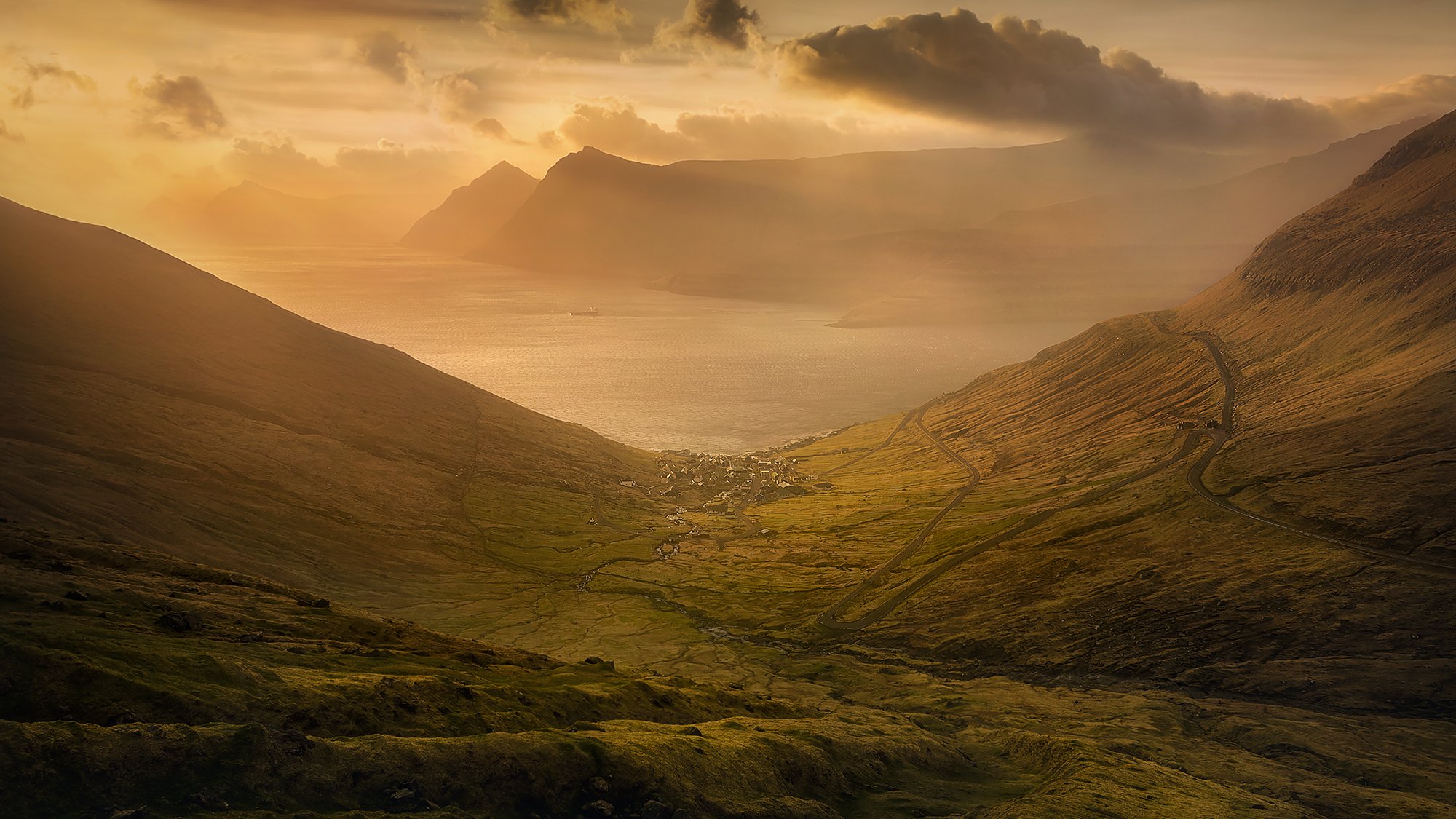
FUNNINGS VILLAGE
After a super windy sunrise on Funningur cliff, I hiked down to the car and follow the mountain road towards village Eiði. Right below the car park, where I started my hike to the mountain, I had to stop again. I just couldn't resist this magnificent vista. Sun was shining with fantastic, morning light, on the fjord and surrounding hills. At the bottom of this gully, you can see the gorgeous village of Funnings. How little it looks in this massive landscape. By legend, the first Viking -Grímur Kamban, who settled on the Faroe Islands, settled right here, in this village. That legend is only adding a magical aura to this magnificent spot.
BORDOY
Bordoy Island is a hidden gem waiting to be discovered by adventurous travelers seeking a serene and unspoiled destination. The island boasts breathtaking landscapes, charming villages, and a rich cultural heritage, making it an ideal destination for nature lovers and cultural enthusiasts alike.
Getting to Bordoy Island can be an adventure in itself, as visitors must travel by boat or helicopter from the mainland of the Faroe Islands. Upon arrival, visitors are greeted by an unspoiled landscape of rugged mountains, steep cliffs, and rolling hills that seem to go on forever. The island is relatively small, with a population of only about 1,200 people, creating a sense of peace and tranquility that is hard to find in other tourist destinations.
One of the main attractions of Bordoy Island is the stunning views from the many hiking trails that crisscross the island. The landscape is wild and rugged, with steep cliffs, waterfalls, and deep fjords. Hikers can enjoy breathtaking views of the sea and neighboring islands, and spot wildlife such as puffins, seals, and whales.
In addition to its natural beauty, Bordoy Island is also home to several charming villages, each with its unique character and history. The largest village on the island is Klaksvík, a thriving fishing port with a bustling harbor and a lively cultural scene. Visitors can explore the village's historic buildings, museums, and art galleries, and sample fresh seafood at one of the many restaurants and cafes.
KLAKKUR
Klakkur Mountain is a prominent peak with an elevation of 555 meters (1,821 feet) and is a popular hiking destination for visitors to the Faroe Islands. The mountain offers stunning views of the surrounding landscape, including the nearby islands of Kunoy and Kalsoy.
The hiking trail to the summit of Klakkur Mountain is challenging but rewarding, with steep inclines and rocky terrain. The trail begins in the village of Árnafjørður and takes hikers through a beautiful valley before ascending to the summit. Along the way, hikers can enjoy the peaceful and unspoiled landscape of Bordoy Island and spot wildlife such as seabirds and sheep.
At the summit of Klakkur Mountain, hikers can take in the stunning views of the surrounding landscape, including the nearby mountains of Lokki and Vaðhorn. On clear days, visitors can see all the way to the neighboring islands of Kunoy, Kalsoy, and Viðoy, as well as the open sea beyond.
On my first morning in Faroes, I decided to go for a little hike. As I wasn't familiar with the places yet, I picked something safe and not very challenging. My apartment was located on Eysteroy island which is a very central place. It was close everywhere, with 30 min drive to all locations except Vagar and South of Streymoy which were a little over 1h away. I woke up at 3.30 am and drove to the second biggest town on the Faroe Islands Klaksvik on the Island of Bordoy. The morning was looking promising but when I walked to the top of Klakkur some unexpected fog came from the South. I waited there 2h, hoping it will clear but nothing like that happened and I have to leave disappointed.
I returned to the same spot two days later in more convenient weather conditions. Already when approaching the summit I had to take the camera out of my bag. Sun bursting with light made the scene look unreal.

A friend, I was traveling with, ran to the edges of the mountain, to suss out what interesting can be found in this area but I simply froze. We, the photographers live for moments like this one. When my companion stood there in awe, I thought having him in the frame worked perfectly to show the scale of this place. The fjords and mountains in the magnificent light of the setting sun looked unreal and I have to say it was one of the best photos I took on my trips. Using long exposure increased the amazing experience of this spectacular location.
Naturally, there are a few more places to visit on Bordoy but unfortunately, I had not enough time or the weather crossed my plans. However, I am happy with what I achieved there anyway. I can definitely recommend visiting Árnafjørður with its spectacular fiord if you plan to do some drone shooting.
KALSOY

The island is accessible by ferry from the nearby village of Klaksvík on the island of Borðoy. Visitors can also explore the island by foot or by car, although the only road on the island is narrow and winding. Kalsoy is known for its rugged and dramatic landscapes, including steep cliffs, rolling hills, and deep fjords. The island is home to several hiking trails that take visitors through some of the island's most scenic and remote areas. Along the way, hikers can spot wildlife such as seabirds and sheep and enjoy the peaceful atmosphere of the Faroe Islands.

Despite lovely sunshine, clouds were still very low, covering most of the summits. That didn't bother me too much and I continued my trip to the small village at the end of Kalsoy called Trøllanes. From there, it was only 30-40 min, not a very challenging hike. I walked around for a good hour just to look at this stunning place from every perspective. The size of the cliff is enormous. If you decided to place a person in the frame it would just disappear. I was there quite early so I sat on the cliff and enjoyed the view, taking shots from time to time as the light conditions were changing.

Around 1h before set, I was ready to shoot the main subject. It cleared but there were still a lot of massive clouds rolling in the sky. It all looked like a big boiling pot. Cliff wasn't so much green yet but I think it was too early for it. Sun was setting behind my back, giving a nice glow to the clouds and the mountain. I was lucky to start shooting early as sunset itself was very pale. This is something I have noticed at all locations. The last minutes of light was not very impressive. It was quite windy so I had to be extremely careful. I dropped my camera twice in this location damaging 2 of my filters but I think that was the minimum punishment I could possibly get for not paying attention. In order to photograph such a huge place, I had to do 4 vertical shots at 19mm and stitched them in a panorama.

I visited this location on two different occasions. The photographs so far presented were shot in April. My second visit in January, was in more dramatic weather conditions as the place was covered by some snow and the wind was my biggest enemy.

It was a real struggle trying to survive on the cliff with gale-force wind, being occasionally bombed with the hailstorm. Luckily for me, it stopped once I reached the destination, allowing me to fly a drone for about half an hour.
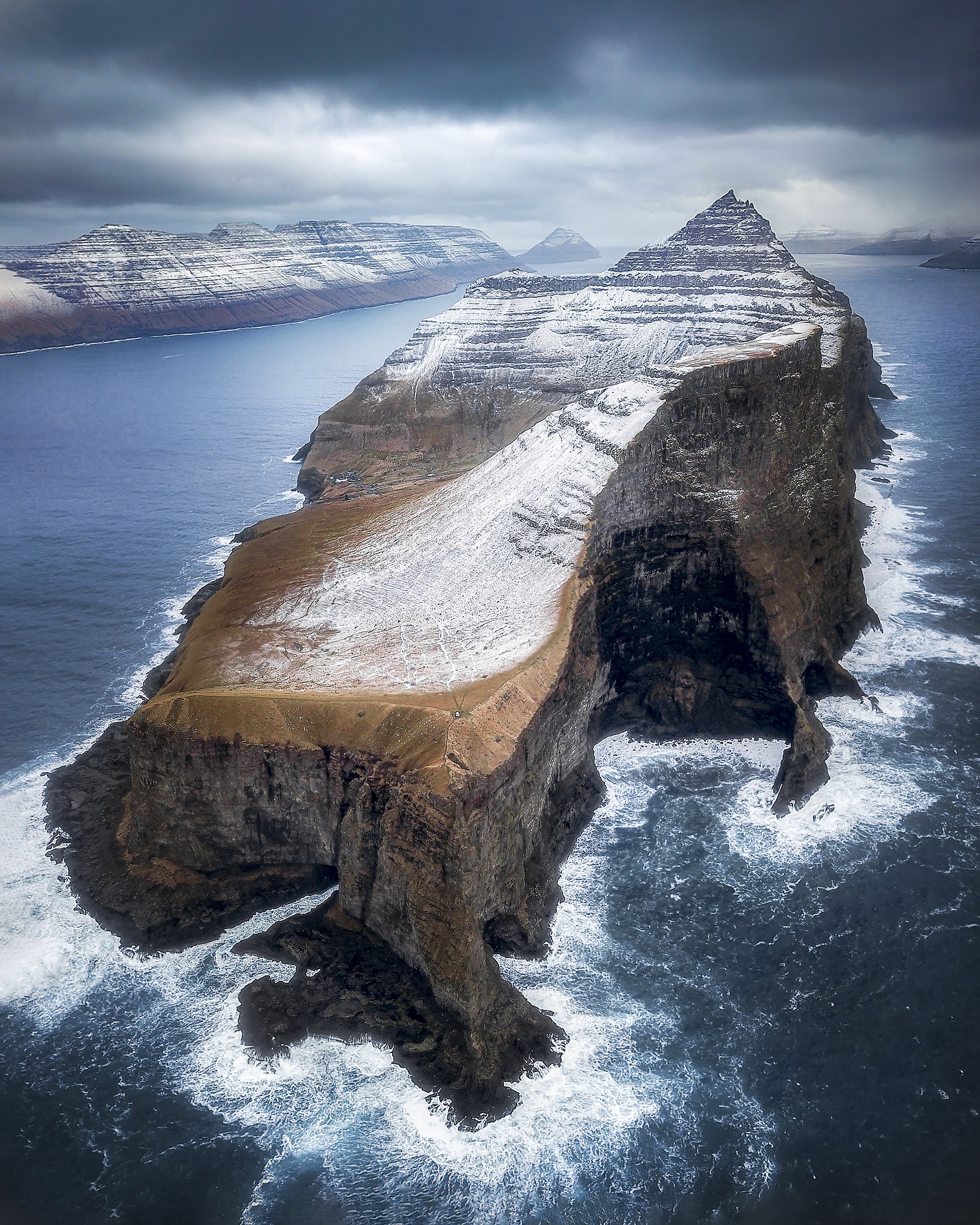
It was truly an amazing experience to see the archipelago from a different perspective. I have to warn you it is not easy to take decent photography there due to the size of the place. In order to achieve some decent results you will have to fly your drone quite high and far away into the Ocean. Even with this, you won’t be able to put everything in one frame. There will be a lot of shooting to cover the entire spectrum but also be great fun. A little windless window allowed me to take the best drone shot in my short drone photography experience.

SANDOY

For the next journey, I would like to take you to one of the Southern islands of the archipelago.
While it perhaps doesn’t have the same dramatic cliff lines that can be found elsewhere in the Faroe Islands, its compact size, charming gingerbread villages, glistening lakes, and sprawling beaches make it a wonderful day trip from Torshavn, and because it seems to be left off so many people’s itineraries, it’s also an excellent place to explore without the crowds.
In just a few hours, you can take in every village and almost every road as you wind between the rolling landscapes, and for those with more time to spare, Sandoy makes an excellent place to set out and explore on foot.
Getting to Sandoy is easy as you just jump on the ferry in Gamlarætt, which is only 20 minute's drive from the capital, and 30 min later you land on the shores of the small island.
Again I didn’t have much time to wander around the Island as I only went there for quick sunset shooting. My first visit was a bit of a disaster as I did not know where exactly was my sunset location. I got lost in the thick fog and returning to the car was quite a challenge. On the second visit, I approached a local farmer who directed me to a beautiful Liraberg cliff.
As you can see the cliff and rock has some similarity with Witches Finger I was photographing on Vagar island. Despite not having the best weather as the sky cleared for a sunset, sitting on this massive cliff was a great experience. Really enjoyable evening.

SUÐUROY

Suðuroy is the southernmost island of the Faroe Islands and also the fourth biggest of the archipelago, with an area of approximately 163 square kilometers, and a population of around 4,500 people. The island is known for its rugged coastline and absolutely spectacular steep cliffs.
During my January visit, I had to battle gale force wind which was an extremely dangerous experience. Photographing was almost impossible and I only managed to visit a couple of spots. I would highly advise booking two, or three days in this magnificent spot. On the next visit to Faroes, I will definitely start my photography from Suðuroy. If you traveling from Edinburgh, your flight will most likely arrive afternoon. It is only 45 min drive to Throshavn where you can catch the last Ferry to Suðuroy, stay a couple of nights there, and book the rest of your visit in the Faroes mainland.
EGGJARNAR
Eggjarnar is a set of cliffs located on the eastern coast of Suðuroy. The cliffs are known for their impressive height and vertical drops into the ocean, which can reach up to 200 meters (656 feet) in some places. The name "Eggjarnar" translates to "Egg Rocks" in English, and it is believed to refer to the shape of the cliffs, which resemble giant eggs.
As much as I wished to spend more time here, it was impossible due to the super high wind. There are lovely rock formations down below but I didn't want the risk. I took quick shots handheld and walked away. As I was heading towards the car and I was away from the cliff already, the gusting wind pushed me to the ground, on my knees like a piece of paper. You can only imagine how difficult it was for me to see all these beautiful spots and not be able to get close to them.

ASMUNDARSTAKKUR
Ásmundarstakkur is a stunning 109 meters high sea stack located on the North West coast of Suðuroy and the views you get near the rock formation are breathtaking. The best view of the sea stack is from the nearby rock cleft Rituskor. In order to get there, you will have to cross a short wooden bridge which is not for the fainthearted. Less courage will do as views of the towering rock formation are just as impressive along the sheer edge.

Because of the gale-force wind, Asmundarstakkur was the only place on Suðuroy island I was able to photograph without losing my life. Pity as this Island is so spectacular and it kept hidden most of its secrets from me. So after visiting a few places I was really convinced I'll come back with nothing.
After crossing the slippery, covered-in green moss rope bridge I could admire this spectacular view. I was really hoping for good sunset in this place but I have to say that moodiness worked just perfectly and I am not sure if I would wish to change on the colorful set.

My journey to the magnificent Faroe Islands came to the end. I was trying to cover the most epic locations I visited during my two trips. There is never enough time to see everything so I hope I will expand this blog one day, enriching it with more locations. I guarantee there is so much more to see and even more to discover. I hope the information included will help you prepare for your first visit and make you fill comfortable and safe.
ENJOY READING!!!
BREAKING LIGHT PICTURES